![]()
Automatic Meteorological Station
About firm
Hydrometeorological stations
Glazed frost warning stations
Camera systems
Map of instalations
Warning sign boards
Recorders
Sensors
Prices
References
Software
Contact us
Meteorological data gauged and stored from longer periods (few years), enable investigation of climate and weather variability. They are essential source of data for scientific institutes working with those problems. Introduction of computers and high quality electronic measuring devices to gauge and storage system considerably rationalises scientists and meteorologists work, giving better results of their efforts.
Automatic Meteorological Station should be installed in the following cases:
- acquisition and storage of data in places difficult to reach by observer,
- acquisition and storage of data in places where observer can not be for longer time,
- reductions of costs related to observer work,
- minimisation of instrument reading errors (human-related),
- specific, continuous type of data acquisition.
Typical set of measured and registered in Automatic Meteorological Station data:
- wind velocity and direction,
- atmospheric pressure,
- air temperature,
- air humidity,
- sun radiation,
- precipitation.
Adding temperature sensors located in soil profile and sensors detecting sun radiation balance, climatic data can be archived.
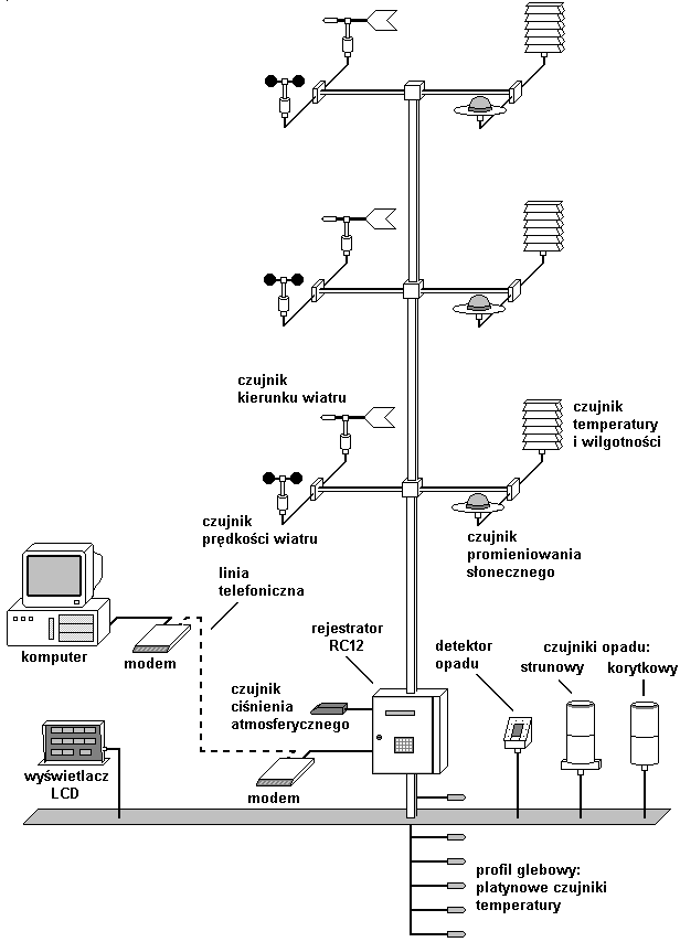
Automatic Meteorological Station constructed on the base of RC12 digital recorder is able to get data from all presented sensors. Measurements are made according to obligatory WMO standard. Data from station can be read by portable notebook, phone modem or radio modem.
Full automation of measurement and storage with remote data reading possibilities, enables use of AMS in local or nation-wide measurement network.
Technical specifications of automatic meteorological station:
- power consumption: 30W,
- supply: 220V, 12VDC or solar battery,
- data storage: 176kB of memory, data logging with programmable measurement period 2-60 minutes,
- data reading: through RS connection directly to computer or by phone (radio) modem.
Technical specifications of typical sensors used in automatic meteorological station:
| Sensor type | Measuring range | Resolution | Accuracy | |
| Relative air humidity sensor (hygrometer) | 30-98% | 0.1% | 2% in range 30-85% 3% inrange 85-98% |
Standard hair from hygrometer 12.5 cm length |
| Relative air humidity sensor (capacitive HMP 35D Vaisal) | 0-100% | 0.1% | 2% in range 0-90% 3% in range 90-100% |
|
| Wind velocity sensor | 0-50m/s | discrimination threshold 0.5m/s | impulse output 20imp/s = 1m/s | |
| Wind direction sensor | 11.5o | discrimination threshold 0.2m/s | output in Grey's code (6 bits) | |
| Direct radiation sensor | 0-1500W/m2 | 10W/m2 | 10% | |
| Air and soil temperature sensor | -40oC do 50oC | 0.1oC | 0.1oC | |
| Atmospheric pressure sensor | 850-1100hPa | 0.1hPa | 1hPa |
Automatic Hydrometeorological Station
Hydrology is the special case of application of meteorological station. It contains apart from meteorological sensors set of water table sensors and aeration zone parameters sensors.
Typical hydrological experimental plot.
Some of hydrogeological stations are equipped with measuring set for measurement in aeration zone (humidity, salinity and temperature at 6 depths).
Automatic Rivers and Water Reservoirs Monitoring Station
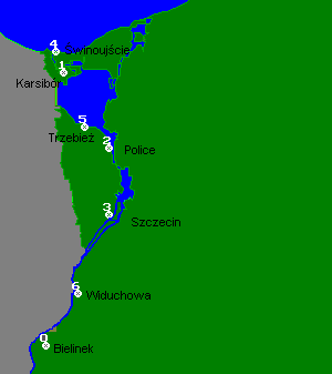 Stations are equipped with water table sensors, atmospheric pressure sensors, wind velocity and wind direction sensors, water and air temperature sensors. Station located at the entrance to Swinoujscie Harbour is additionally equipped with water flux velocity and direction sensors and salinity sensors.
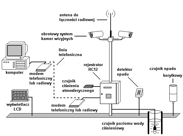
Data from station are transmitted directly to Harbours Master's Office and observation points situated along water way. It ensures safe control and tracing of water transport. Stations are equipped with telephone modems. It enables data transmission to other recipients.
If there is a video system installed, also images can be sent from selected point.
Selected Watersheds Monitoring System
Location of automatic hydrometeorological stations in upper parts of the watersheds enables construction of flood hazard warning system.
Basic equipment of the station includes precipitation sensor, water table sensor and RC12 digital recorder. Additionally station can be equipped with video camera, and in special cases with other meteorological sensors. Station can be supplied from solar batteries and set of accumulators.
For communication regular telephone line (TP S.A.), GSM phones, Centertel or radiomodems can be used.
Regional Directories of Water Management branch offices equipped with adequate software, can receive current information from all gauge point covering certain area. Real-time tracing of measurement results enables early detection of intensificated rainfalls and resulting flooding. In case of big-scale flood such a system enables early warning of appropriate services and citizens.